- Go about 2 miles to New Circle Rd. 4 (a very wide intersection, watch the signs).
- Turn left onto the New Circle Rd. 4 ( it loops around Lexington).
- Go to the Rt. 68 exit and turn left.
- Rt. 68 will eventually take you to Perryville (be careful at the "Y" intersection in Harrodsburg; read the signs; don't turn on Rt. 152).
- Once at the intersection of Rt. 68 and Rt. 150 in Perryville, turn right onto Rt. 150.
- Go about a quarter mile and turn right onto Mackville Rd. (you will see a big sign for the battlefield here).
- Go about 3 miles to the park entrance, it is on your left.
SECOND ROUTE:
- Take I-75 South to Exit 110 near Lexington.
- Turn right onto Rt. 60.
- Go about 2 miles to New Circle Rd. 4 (a very wide intersection, watch the signs).
- Turn left onto the New Circle Rd. 4 ( it loops around Lexington).
- Go to the Rt. 27 exit to Nicholasville Rd. and turn left to Nicholasville.
- Take the Rt. 27 by-pass around Nicholasville (for your information, Camp Nelson is just past here on your left).
- Take Rt. 27 a good ways until you see a country BP station, Rt. 34 junctions off just past it. Turn right onto Rt.34. This will take you into the back side of Danville.
- Rt. 34 is known as Lexington Rd. in Danville. In town, it will turn sharply to the right into the historic home district.
- Once you turn here, go about a half mile and watch for Fourth Street on your left side.
- Turn left on Fourth St. and go about 2 blocks and turn right onto Rt. 150.
- Go about 10 miles into Perryville and watch for the Mackville Rd. a quarter mile past town. Turn right here and go about 3 miles to the park entrance. It is on the left.
The second route will seem long here, but is actually shorter. If you prefer the long scenic route of Rt. 68, then choose the first route.
Spring Grove, OH
From the north (Columbus) take I-71 south to I-275 west.
- Take I-275 west to I-75 south.
- Take I-75 south to Mitchell Ave. (exit #6).
- Go west on Mitchell Ave. (keeping to your left) roughly 2/10 of a mile.
- You will want to turn left on to Springrove Ave. at the light, just pass the railroad overpass.
- Go south on Springrove Ave. roughly a 1/2 mile.
- The cemetery is on your right just past the Winton Rd. intersection.
- Enter the cemetery and follow the road straight in under the railroad overpass.
- Take the first right past the overpass. The Civil War section us just ahead on the left as the road curves.
From Daytonjust follow the above from I-75 south.
From Kentucky and other parts of the south, just come north on I-75 to the Mitchell exit and follow the above.
Dinsmore House, Burlington, KY
Take I-71 or I-75 south into Kentucky.
- Follow I-75 to exit 181 (Rt. 18 - Florence/Burlington).
- Follow Rt. 18 west to Burlington, KY, and then continue another 6.5 miles west to the Dinsmore Homesead.
- The house will be on your right.
Sharon Woods
From Dayton
- South on I-75
- East on to I-275
- Take exit 46 (Sharonville/Rt. 42 exit) turn right
- Go south about one mile
- Cross Kemper Rd.
- Watch for sign to Sharon Woods in less than a 1/4 mile--turn left
- The entrance people can direct you to the Heritage Village
From Columbus
- South on I-71
- West on to I-275
- Take exit 46 (Sharonvill/Rt. 42 exit) turn left
- Go south about one mile
- Cross Kemper Rd.
- Watch for sign to Sharon Woods in less than a 1/4 mile-- turn left
- The entrance people can direct you to the Heritage Village
From Cincy/ N. Ky
- Take I-275
- Take exit 46 (Sharonville/Rt. 42 exit) turn right if you are going east, turn left if your going west
- Go south about one mile
- Cross Kemper Rd.
- Watch for sign to Sharon Woods in less than a 1/4 mile--turn left
- The entrance people can direct you to the Heritage Village
Camp Dennison - School House
Take I-71 or I-75 to I-275 East
- Go East on I-275 all the way to Exit 54 - "Wards Corner Road"
- Turn Right on to Wards Corner Road and follow nearly 1 mile to Rt.126. You are now in Miamiville.
- Turn Left onto Rt. 126 (or Center Street in Miamiville) and go about 1/4 -1/2 mile to a 3-way stop sign.
- You should see a mom and pop mini mart on the right. Turn right at the stop sign as this is Rt.126 continued.
- Go another 3/4 mile or so into Camp Dennison. You will see a sign for CD, and just past it an enter sign for
the School House Restaurant. Turn right here and follow the entrance behind the school. Park anywhere
in back. Walk to the front entrance and head up the stairs to your right. Remember you are in uniform and
the rules of etiquette shall apply. Ladies will be present.
Blue Ash Air Guard Armory
Take I-75 or I-71 to I-275
- If you are coming I-71, go west on I-275 and exit at Reed Hartman Highway.
- Turn south and go to Creek Rd. It is about 1 mile south. Turn right at stop light, turn left at stop sign.
- The Armory in on the right,
From I-75, go east on I-275, exit at Reed Hartman Highway. Then continue with the above directions.
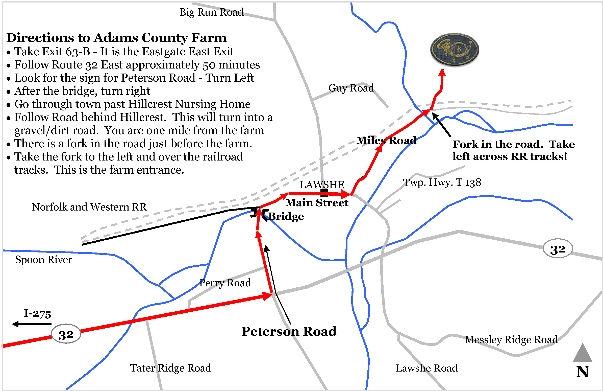
Training Camp in Adams County
Newark, OH - (Granville,OH)
The idea here is to get to I-70 east of Columbus. Some of you quick thinkers might even want to use I-270 to help you get around the big city.
- Once you are east on I-70 heading away from Columbus, watch for the exit for State Route 37. Get off at this exit and head north up Rt. 37.
- Go about 7 miles and you will see The Infirmary Mound on your right. If you run into Rt. 16, then you have gone too far.
- Once you are in the park, go towards the back. You will see a marked off grass lot to park in. However, there is an access entrance for reeactors straight ahead. Event sign in will be at the left at the entrance. Sign in.
- The 6th will be over towards the left and down, at the wood line. You are allowed to drive to our site on Friday and drop off whatever you want (should only be coolers since we are campaigning). Return back to the grassy lot for parking.
Buffington Island
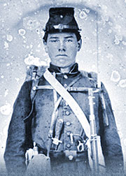
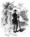
Upper left: Unidentified Ohio enlistedman, image courtesy of Alan E. Hoeweler
From Cleveland:
- South on I-77 to Ravenswood Exit; Turn right on WV Rt.2;
- Turn right on WV Rt. 68 and right again at the ramp for the Ohio river bridge.
- Cross the bridge and turn right on Ohio St.Rt. 338.
- Continue north after 338 connects with Rt. 124 for appx. 3 miles.
From Columbus:
- South on US 33 to Pomeroy; North on St.Rt. 124 to Portland, appx. 20 minutes from Pomeroy.
From Cincinnati/ Northern Kentucky:
- St.Rt. 32 to Athens; South on US 33 to Pomeroy; North on St.Rt. 124 to Portland, appx. 20 minutes from Pomeroy.
The park where the encampment is located is appx. 5-6 miles north of the Ravenswood, WV bridge, on Ohio St.Rt. 124.
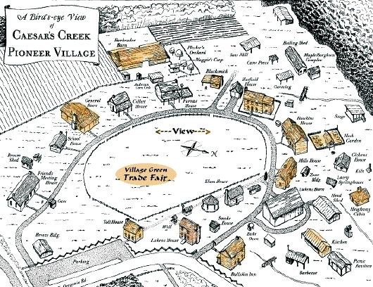
Caesar's Creek, OH
From Cincinnati, Ohio:
-I-71 North to State Route 73, Turn left onto SR 73, Turn left onto Oregonia Road, then right onto Pioneer Village Road.
From Columbus, Ohio:
-I-71 South to State Route 73, Turn right on SR 73, Turn left onto Oregonia Road, then right onto Pioneer Village Road.
Please note that the parking area shown fills up quickly. There is overfill parking where the big red "X" is placed.
Gilardi's Field in West Harrison, IN
From North or South:
- Work your way to I-275 and head west towards Indianapolis.
- Merge over to I-74 west and take it to Exit 1 to New Haven Rd. You will see Cracker Barrel and Home Depot
on the right.
- Turn right onto New Haven Rd. Go a quarter mile to the second intersection (passing Home Depot). There
will be a blinking four way stop light. The crossing road is Carolina Trace. Turn left here.
- Stay on Carolina Trace. Go through two stops staying on Carolina Trace. After 4 or 5 miles, you will cross
into Indiana (road surface changes drastically). After another mile or so, past a large grain and feed mill, there
will be a 90 degree left bend. Shortly after you will come to Kentucky Avenue on the left, just as the road turns
sharply to the right.
- Turn left onto Kentucky Avenue. Look for two mailboxes on the right. One will say 1072 Gilardi, the other will
say 1074 Getz. Turn right. Take the right fork in the driveway. Go way back and turn around in the circle (you
will see Tony's house on the right). Park along the driveway to one side (left) facing back toward the road. We don't want to block his driveway from access. Camp is directly in the pasture across from his house.
Camp Friedlander Boy Scout Camp
Take I-71 or I-75 to I-275 East
- Go East on I-275 all the way to Exit 54 - "Wards Corner Road"
- Turn Right on to Wards Corner Road and follow nearly 1 mile to Rt.126. You are now in Miamiville.
- Turn Left onto Rt. 126 (or Center Street in Miamiville) and go about 1/4 -1/2 mile to a 3-way stop sign.
- Proceed straight ahead and up the hill.
- Watch for and turn onto Ibold Rd.
- Watch for entrance to Camp Friedlander on the right ( maybe a mile or so).
X
Chillicothe Veteran's Day Event
- Find 35 east and follow directions from Top.
From Cincinnati
- I-71 north to US 35 east into Ross County.
- Exit at (state route 104) High st. turn right and get into the left lane, continue on High St. (aprox. 1 mile)
till the fourth traffic light and turn left onto Mill street.
- Go thru one traffic light and enter Yoctangee park ( YMCA will be on your right).
- Continue another 100 yards and turn left onto Enderlin Circle.
- Travel another 100 yards and look for a gravel parking lot by a baseball diamond.
From Columbus
- Take 23 south to the Main street exit and turn right.
- Go aprox. 1.8 miles (9 traffic lights) and turn right onto Walnut street.
- Continue thru two traffic lights-you're now on Yoctangee pky.
- Continue in right lane up till the YMCA, turn right on Mill St.
- Go about 100 yds. and turn left onto Enderlin Circle.
- Go another 100 yds. and look for gravel parking lot on left.
From Waverly
- Take 23 North to Main street exit and turn left.
- Go thru 10 traffic lights and follow directions from above starting at Walnut.